
Siamo spiacenti, questo articolo non è disponibile nella lingua scelta. EN abort
Ascent to the peaks of the Slepičí Mountains
What would the Chicken Mountains be if their highest peak was not called Kohout, with an altitude of 871 metres.
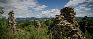
Only a few years ago, the view from the top could be seen from the gallery of an old wooden lookout tower, but nowadays there is only an inaccessible transmitting tower on the top and the place is wooded. However, in addition to the tower, the summit also features a trigonometric point, which was marked here during the 1867 land survey. This point is said to be the geographical centre of Europe. The neighbouring Vysoký kámen, better known by the popular name Slepice (865 m), offers more interesting views at the top. The red hiking trail, which leads visitors to Slepice in the direction from Benešov nad Cerna, leads along the so-called Heavenly Steps and the rock ridge at the end. According to legends, fire signals were sent from the mountain to the surrounding area and the mountain was a cult place during the Celtic times. It is possible to use routes from other directions to climb Slepica. The yellow trail leads from the east from the Klení, from the west the red trail or cycle path 1187 from Děkanské Skaliny, through Velké Skaliny, Daleké Popelice and Myslivna pod Kohoutem, where the crossroads is located: north climb to Kohout and south (after about a hundred metres on the asphalt road turn right) climb to Vysoký kámen.
Lunghezza totale
14 Km
Requisiti di tempo
Half a day
Terreno
Unpaved roads
Periodo di visita consigliato
Spring, summer, autumn
Esigenza fisica
Moderately challenging
Come arrivare in cima
By car, by bus, by bike
Come tornare indietro
By car, by bus, by bike
Punti di interesse sul percorso
Besednice - Museum of Horse Harnesses
Soběnov - Church of St. Nicholas
Valley of the Black Valley Educational Trail