


Historical Album of the Šumava
Discover the history of the Šumava.
Inseparable from the Šumava region are the vanished villages and the turbulent stories of their inhabitants. Over the centuries, humans gradually shaped the original wild nature into their own image. After the forced expulsion of the German population and the establishment of the “Iron Curtain” on our western border, the land was returned to nature. The result of this combination of cultural and natural landscape is now considered beautiful and unique. Who would think that houses once stood in the forests of Gsenget? Who today knows how people in Paště made their living? Was the dam of Plešné Lake really uninhabited? The "historical albums" bring the lives of settlers closer to visitors, right at authentic locations. The value of these images – in this case photographs – often speaks louder than a thousand words.
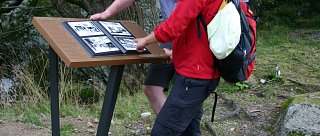
Information panels are located at 30 selected sites.

Seznam „zmizelých" míst
Česky /tschechisch | Německy / deutsch | GPS mapa | |
| 1. | Zhůří (tzv. Kepelské) | Haidl am Ahornberg | 49°10'36.164"N, 13°20'7.701"E |
| 2. | Frauenthal | Frauenthal | 49°8'29.173"N, 13°23'39.769"E |
| 3. | Skelná | Glaserwald | 49°9'24.633"N, 13°23'3.807"E |
| 4. | Paseka | Holzschlag | 49°9'10.680"N, 13°21'16.430"E |
| 5. | Hůrka | Hurkenthal | 49°7'38.646"N, 13°19'51.045"E |
| 6. | Vysoké Lávky | Hohenstegen | 49°7'47.248"N, 13°22'35.932"E |
| 7. | Horní Ždánidla | Ober-Steindlberg | 49°5'15.019"N, 13°21'10.121"E |
| 8. | Velký Bor | Grosshaid | 49°6'9.401"N, 13°25'49.462"E |
| 9. | Zelená Hora | Grünberg | 49°4'53.354"N, 13°26'10.496"E |
| 10. | Stodůlky | Stadln | 49°7'14.665"N, 13°25'59.541"E |
| 11. | Prostřední Paště | Mitter-Waid | 49°7'9.494"N, 13°28'35.221"E |
| 12. | Javoří Pila | Ahornsäge | 49°2'14.918"N, 13°26'32.854"E |
| 13. | Vchynice-Tetov | Chynitz-Tettau | 49°1'49.228"N, 13°29'48.741"E |
| 14. | Hraběcí Huť | Grafenhütte | 49°0'31.257"N, 13°34'6.985"E |
| 15. | Zhůří (u Rejštejna) | Haidl | 49°5'18.356"N, 13°33'15.590"E |
| 16. | Františkov | Franzensthal | 49°0'15.086"N, 13°36'47.922"E |
| 17. | Knížecí Pláně | Fürstenhut | 48°57'10.241"N, 13°36'56.958"E |
| 18. | Žďárek | Scheuereck | 48°55'34.539"N, 13°38'40.481"E |
| 19. | Horní Světlé Hory | Ober-Lichtbuchet | 48°54'15.386"N, 13°40'9.282"E |
| 20. | Polka | Elendbachl | 48°56'49.122"N, 13°42'46.270"E |
| 21. | Březová Lada | Birkenhaid | 48°57'18.575"N, 13°42'50.430"E |
| 22. | Radvanovice | Schillerberg | 48°53'9.428"N, 13°46'8.936"E |
| 23. | Dolní Cazov | Unter-Zassau | 48°53'10.727"N, 13°44'33.240"E |
| 24. | Krásná Hora | Schönberg | 48°51'13.380"N, 13°45'59.022"E |
| 25. | Nové Údolí | Neuthal | 48°49'43.803"N, 13°47'55.808"E |
| 26. | Jelení Vrchy | Hirschbergen | 48°48'59.645"N, 13°52'40.293"E |
| 27. | Josefův Důl | Josefsthal | 48°43'56.359"N, 13°58'25.471"E |
| 28. | Huťský Dvůr | Hüttenhof | 48°44'29.778"N, 13°58'10.493"E |
| 29. | Zadní Zvonková | Glöckelberg | 48°43'24.194"N, 13°58'57.649"E |
| 30. | Plešné jezero | Plöckensteiner-See | 48°46'40.410"N, 13°52'3.142"E |
The Šumava National Park wishes you joy and memorable experiences in nature as you explore the lives of Šumava's former inhabitants.
Text published by: Šumava National Park Administration, 2016
Author: Mgr. Josef Štemberk
Photo: © Mgr. Josef Štemberk