
Geocaching in the Novohradské Mountains – Rock Trail
The Rock Trail is the third route where you can find three more caches in the Novohradské Mountains.
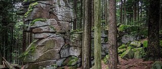
It starts and ends at Hojná Voda and during the hunt you will reach the summit of Vysoká, which is 1,033 meters above sea level, and then continue to the Hojnovodský Primeval Forest, one of the oldest European primeval forests (established in 1838). Although you will encounter monumental rock formations along the trail, the route is not very difficult. Its length is 9.8 km, and during the hike, you will overcome an elevation gain of 354 meters.
The caches on the Rock Trail are located at:
GPS: 48° 42‘ 54.50“ N; 14° 44‘ 20.15“ E
GPS: 48° 42‘ 9.60“ N; 14° 44‘ 44.78“ E
GPS: 48° 42‘ 24.42“ N; 14° 45‘ 9.84“ E
Total length
9.8 km
Duration
About 3 hours
Terrain
Unpaved and paved paths, mostly through forest
Recommended period for visiting
Spring, summer, autumn
Difficulty level
Moderate
Marking
None
How do you get to the start
Hojná Voda, accessible by car or public bus — route České Budějovice – Trhové Sviny – Nové Hrady – Hojná Voda
How to get back
By car or bus from Hojná Voda
Interesting places on the route
Hojnovodský Primeval Forest
The settlement of Hojná Voda and the Bell of Gathering
The lookout tower on Kraví hora