


Geocaching in the Novohradské and Doudlebské Regions
In the Novohradsko-Doudlebsko tourist area, we have prepared ten hiking routes that will také you to interesting and often still undiscovered places. And to make your journey even more exciting, we have hidden three caches along each trail.
The first route we’d like to introduce is the trail around the Černá River. This river originates under the name Schwarzaubach in Austria and flows into the Malše River near Kaplice. Along the trail, you will not only find fascinating waterworks but can also visit the ruins of Sokolčí Castle or the lookout tower on Hradišťský Hill.
The trail, about 10 km long, starts and ends in the village of Blansko, located 1.5 km east of Kaplice. You can reach it by bus or by car, which can be parked in the parking lot near the village square.
We recommend doing this trail strictly on foot due to the terrain; strollers are definitely not suitable here. The trail is not overly demanding and will také you about half a day. Of course, the time depends on how long it takes you to find the three caches. They are located at:
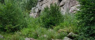
- First cache: After crossing the bridge near the power station, you will see a slope with rock formations where the first cache is hidden. On the map, this spot is marked with number 2.
- Second cache: Hidden in the ruins of the Gothic Sokolčí Castle, marked on the map as number 3.
- Third cache: Located near the lookout tower on Hradišťský Hill, in the forest under the tourist shelters. On the map, it is marked as number 4.
Total length
10 km
Duration
Half a day
Terrain
Moderately challenging
Recommended period for visiting
Summer
Difficulty level
Moderately challenging
How do you get to the start
By car
How to get back
By car
Interesting places on the route
Fascinating waterworks (such as the Soběnov Reservoir)
Ruins of Sokolčí Castle
Lookout tower on Hradišťský Hill