


VCC – Stage 1: From the Source of the Vltava to Nová Pec
This is the main backbone route of South Bohemia, which does not end at the regional border but continues all the way to the confluence of the Vltava and the Elbe at Mělník, where its journey ends after more than 450 km. The Vltava River and its surroundings take on many forms – it can be calm and gentle, but also harsh and wild. Along the way, you will encounter a variety of landscapes, from the rugged mountain terrain of the Šumava with its deep forests, through the vast water surface of the “South Bohemian Sea,” to the Budějovice Basin. You will also come across many human-made structures built over the centuries. In many parts, it is a high-quality and pleasant cycle path, while in others you will ride along quiet side roads or forest tracks. The total length of the South Bohemian section is approximately 261 km, and the route is of medium difficulty, suitable for trekking bikes.
PRAMEN VLTAVY – KVILDA – KNÍŽECÍ PLÁNĚ – HORNÍ VLTAVICE – LENORA – STOŽEC – NOVÁ PEC
Total length
61 km
Terrain
Elevation gain: 353 m
Descent: 797 m
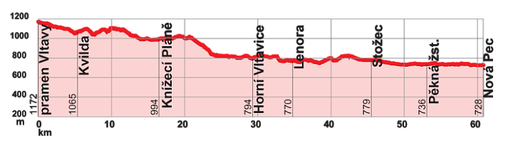
Interesting places on the route
- Source of the Vltava River
- Kvilda – Visitor and Information Center of the Šumava National Park
- Knížecí Pláně – Church
- Idina Pila – Information Point of the Šumava National Park
- Lenora – Rechle (wooden river log-driving bridge), chateau, Glass Museum
- Stožec – Information Center