


VCC – Stage 2: From Nová Pec to Vyšší Brod
This is the main backbone route of South Bohemia, which does not end at the regional border but continues all the way to the confluence of the Vltava and the Elbe at Mělník, where its journey ends after more than 450 km. The Vltava River and its surroundings take on many forms – it can be calm and gentle, but also harsh and wild. Along the way, you will encounter a variety of landscapes, from the rugged Šumava mountain region with its deep forests, through the vast water surface of the “South Bohemian Sea,” to the Budějovice Basin. You will also come across many structures built by human hands over the centuries. In many parts, this is a high-quality and pleasant cycle path, but you will also encounter segments along quiet side roads or forest paths. The total length of the South Bohemian section is approximately 261 km, and the route is moderately difficult, suitable for trekking bikes.
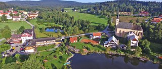
NOVÁ PEC – ZADNÍ ZVONKOVÁ – SCHWARZENBERG CANAL – VÍTKŮV KÁMEN – PŘEDNÍ VÝTOŇ – LOUČOVICE – VYŠŠÍ BROD
Total length
47 km
Terrain
Elevation gain: 321 m
Descent: 490 m

Interesting places on the route
- Nová Pec – Information Centre
- Zadní Zvonková – Church, Museum
- Schwarzenberg Canal
- Vítkův Kámen – Lookout tower
- Přední Výtoň – Church
- Loučovice – Devil's Wall (Čertova stěna)
- Vyšší Brod – Monastery, Stations of the Cross, Museum