


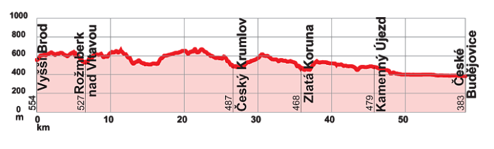
VCC – Stage 3: From Vyšší Brod to České Budějovice
This is the main backbone route of South Bohemia, which does not end at the region's border but continues all the way to the confluence of the Vltava and Elbe rivers near Mělník, where its over 450 km journey comes to an end. The Vltava River and its surroundings have many faces – it can be calm and gentle, but also rugged and stormy. Along the way, you will experience various landscapes, from the rugged Šumava mountain terrain with deep forests, through the vast water surface of the "South Bohemian Sea," to the Budějovice Basin. You will also encounter numerous human-made landmarks developed over the centuries. In many sections, it is a very high-quality and pleasant cycle path, but you will also come across stretches on quiet side roads or forest tracks. The total length of the South Bohemian section is about 261 km and the route is moderately difficult, suitable for trekking bikes.
VYŠŠÍ BROD – ROŽMBERK NAD VLTAVOU – ZÁTOŇ – ČESKÝ KRUMLOV – ZLATÁ KORUNA – BORŠOV NAD VLTAVOU
Total length
58 km
Terrain
- Ascent: 870 m
- Descent: 1041 m
Interesting places on the route
Vyšší Brod – monastery, Opat’s Trail
Rožmberk nad Vltavou – castle and chateau
Zátoň – church
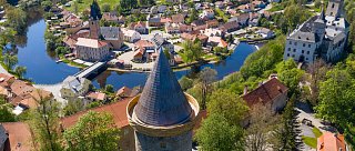
Český Krumlov – chateau, historic centre
Zlatá Koruna – monastery
Boršov nad Vltavou – Stations of the Cross