

VCC – Stage 4: From České Budějovice to Kluk
This is South Bohemia’s main backbone route, which does not end at the region's border but continues all the way to the confluence of the Vltava and Elbe Rivers at Mělník, where its journey of over 450 km ends. The Vltava River and its surroundings have many faces – it can be calm and gentle, but also harsh and tempestuous. Along the way, you will encounter a variety of landscapes, from the rugged mountain terrain of the Šumava with deep forests, through the large water surface of the “South Bohemian Sea,” to the Budějovice Basin. You will also come across many human-made landmarks created over centuries. In many sections, it is a high-quality and pleasant cycle path, though some parts run along quiet side roads or forest tracks. The total length of the South Bohemian section is about 261 km and the route is of medium difficulty, suitable for trekking bikes.
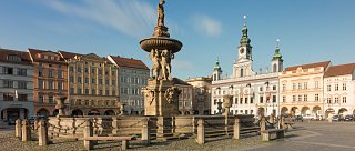
České Budějovice – Hluboká nad Vltavou – Purkarec – Temelín Nuclear Power Station – Týn nad Vltavou – Albrechtice
Total length
59 km
Terrain
Elevation gain: 760 m
Descent: 694 m

Interesting places on the route
České Budějovice – Historical center, breweries
Hluboká nad Vltavou – Castle, zoo
Purkarec – Rafting museum
Temelín NPP – Visitor center
Týn nad Vltavou – Confluence of the Vltava and Lužnice Rivers
Albrechtice – Chapel cemetery