

Climb to Poluška
Despite its picturesque scenery and natural integrity, Poluška remains one of the touristically overlooked areas compared to more famous parts of the southeastern Bohemian Forest (especially the nearby Lipno), with underdeveloped tourist infrastructure.
However, interest is gradually increasing among hikers and cyclists who are not demanding in terms of services and are content, for example, with accommodation on a family farm. The main starting points for accessing the Poluška area are the villages of Omlenice and Věžovatá Pláně.
From the center of Věžovatá Pláně, you can quickly join the red tourist trail marked by the Czech Tourist Club (KČT), which leads past Brusnické Chalupy almost to the top of Poluška (919 m), where a transmitter prevents access directly to the summit. The return route follows forest paths below the former ski area Kozí Pláň, through the village of Dolní Pláně, and climbs back to the starting point.
The Poluška Nature Park was declared by the District Office of Český Krumlov on 23 August 1999 and confirmed by the South Bohemian Regional Council on 6 April 2004. The purpose of the park is to protect the landscape character of the mountain ridge between the Vltava and Malše rivers. The natural and aesthetic value of the landscape is shaped by an almost untouched forest ecosystem, meadow ecosystems, hedgerows, groves, tree stands, and preserved traditional architecture of residential and agricultural buildings, hamlets, and homesteads.
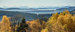
The territory of the Poluška Nature Park belongs to the geomorphological subunit Rožmitál Highlands in the Bohemian Forest Foothills with its highest peaks being Poluška (919 m a.s.l.), Kraví hora (909 m a.s.l.), and Hůra (799 m a.s.l.)
Total length
8.5 km
Duration
Half-day trip
Terrain
Unpaved paths
Recommended period for visiting
Spring, summer, autumn
Difficulty level
Moderately demanding